FPNA reviews land use proposals affecting our neighborhood across the City of Portland and Multnomah County. We automatically receive land use notices about development within our boundary and can appeal decisions at the city level without charge.
Current status of the Harborton Phase 3 case — a coalition effort that protected Forest Park from a proposed transmission expansion.
Updated July 6, 2026.
The City of Portland has signed an agreement with Portland General Electric that clears a path for PGE to refile its Harborton Phase 3 application. FPNA, together with the Forest Park Conservancy and the Bird Alliance of Oregon, was excluded from the final negotiations and did not sign the deal.
The three organizations have issued a joint press release opposing the agreement. In it, the coalition states that the deal gives the public no clear oversight over how mitigation funds will be spent, directs City staff to write a favorable staff report, and falls short of the City’s own conservation goals for Forest Park. The revised project would still remove 376 trees across 4.7 acres of mature forest in the park’s North Unit, fill wetlands, disrupt streams, and narrow the wildlife corridor.
Under the agreement, PGE would pay the City $5.5 million for mitigation, which is $3.1 million more than the $2.4 million fee-in-lieu in the original application. The coalition had proposed dedicating at least $2 million more specifically to protecting and restoring land in the wildlife corridor north of the park, with oversight shared among the City and conservation partners. That proposal was not adopted.
Read the joint press release (PDF) →
Read the coalition’s April 30 letter to the City and PGE (PDF) →
Make your voice heard. The coalition is urging neighbors to tell City Council they oppose this deal and to ask that the public keep a meaningful role in reviewing any revised PGE application. Contact City Council →
District 4 (your representatives, Forest Park)
Councilor.Clark@portlandoregon.gov (Vice President Olivia Clark)
Councilor.Green@portlandoregon.gov (Mitch Green)
Councilor.Zimmerman@portlandoregon.gov (Eric Zimmerman)
District 1
Councilor.Avalos@portlandoregon.gov (Candace Avalos)
Councilor.Dunphy@portlandoregon.gov (Jamie Dunphy)
Councilor.Smith@portlandoregon.gov (Loretta Smith)
District 2
Councilor.Pirtle-Guiney@portlandoregon.gov (Council President Elana Pirtle-Guiney)
Councilor.Kanal@portlandoregon.gov (Sameer Kanal)
Councilor.Ryan@portlandoregon.gov (Dan Ryan)
District 3
Councilor.Koyamalane@portlandoregon.gov (Vice President Tiffany Koyama Lane)
Councilor.Morillo@portlandoregon.gov (Angelita Morillo)
Councilor.Novick@portlandoregon.gov (Steve Novick)
Support the work. FPNA’s land use work, including appeals, comment letters, and legal review, is funded by neighbors and partners. Contributions are tax-deductible to FPNA as a 501(c)(3) Oregon nonprofit. Donate to Save Forest Park →
PROJECT AREA MAP + CAPTION
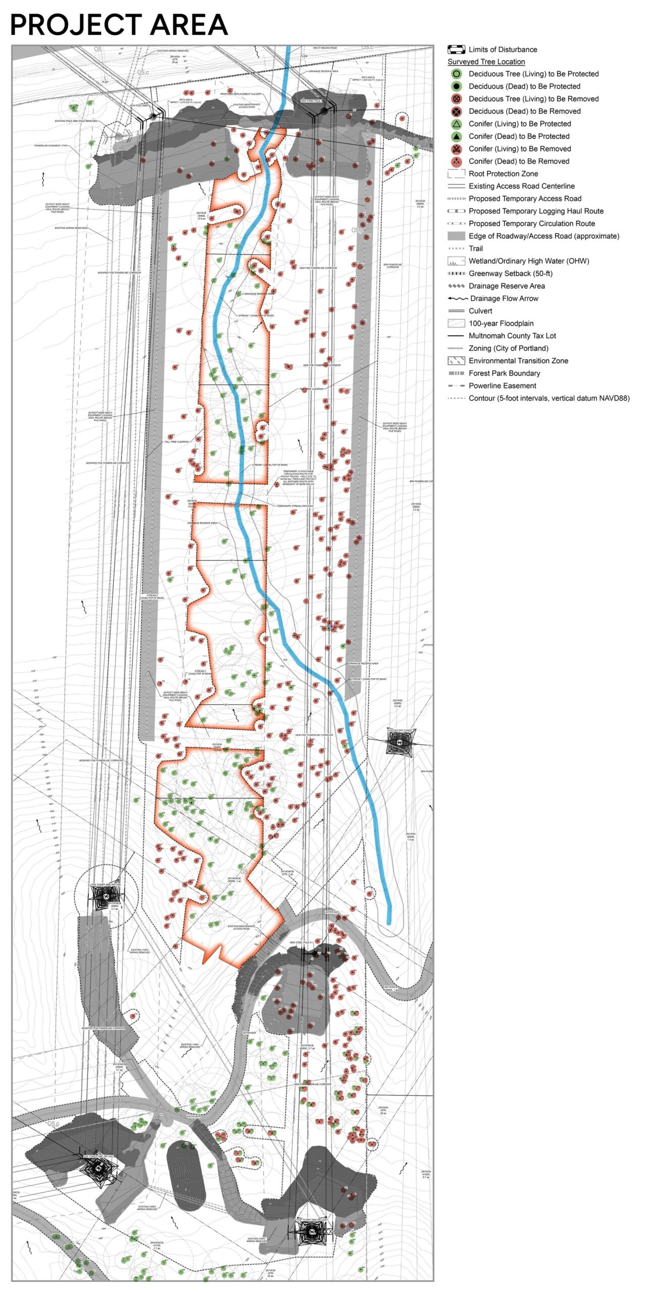
Understanding the Project Area map
FPNA created this map to help neighbors see what PGE’s Phase 3 project would do to Forest Park’s North Unit. It assembles diagrams from PGE’s own land use application, PGE’s Arborist Tree Protection Plan and Exhibit E, which split the project area across several pages, and adds color, outlines, and a legend to show how the pieces fit together and what would be lost.
The blue line is the creek. The orange outlines mark the three small areas that would be protected from disturbance during construction. Trees inside those orange areas are generally left standing, though some would be topped. Everything outside them in the project area would be removed. In all, PGE’s revised application would remove 376 trees.
The long light-grey lines running alongside the protected areas are the two largest logging roads PGE proposes to build to move machinery into the site. The other grey shaded areas show where the ground would be graded, mostly around the towers and poles, along with staging areas.
Seen as a whole, the map shows how little forest would remain: three thin patches of protected trees surrounded by removal and new logging roads, cutting through habitat along the creek that connects the northern and southern parts of the park.
See the source documents. FPNA built this map from PGE’s own application exhibits. You can review them directly:
Note: PGE’s resource page includes the Hearings Officer decision that approved the project and the comments supporting it. Based on FPNA’s review, it does not include the final City Council decision denying the application or the public comments opposing the project.
Base diagrams from PGE’s Phase 3 land use application (Exhibit E and Appendix B, Arborist Report). Map assembled and prepared by FPNA to illustrate the project’s impacts.
Case LU 24-041109 CU EN
FPNA's land use work — appeals, comment letters, and legal review — is supported by donations from neighbors and partners. Contributions are tax-deductible to FPNA as a 501(c)(3) Oregon nonprofit.
Prefer to send a check? Make payable to "Forest Park Neighborhood Association" and mail to the District Four Coalition address (see Contact).
The Forest Park Natural Resources Management Plan (NRMP) is the City of Portland's governing document for activities in Forest Park. FPNA helped write it — and it remains the substantive standard against which projects affecting the park are judged today.
The NRMP sets the rules for what can and cannot happen in Forest Park — from trail work and habitat restoration to utility infrastructure decisions like the PGE Harborton case above. Any project affecting the park is evaluated against the NRMP's three management zones and its substantive standards.
The NRMP was developed between 1994 and 1995 by Portland Parks and Recreation and the Bureau of Planning. Development was overseen by a Citizens Advisory Committee with representation from neighborhood associations, conservation groups, and city staff. The plan was adopted by City Council in February 1995 (Ord. 168509).
FPNA was represented on the Citizens Advisory Committee that helped develop the NRMP. The work of writing the plan three decades ago is a substantial part of what makes effective land use advocacy possible today.
The NRMP is organized in eight chapters covering background and policy, existing natural resources, three management zones, and implementation. Plan Summary and Implementation are the most useful starting points for residents trying to understand how a specific project will be evaluated.
The most recent neighborhood-wide record of what FPNA residents value — and how they want the area to be protected from further urban growth boundary expansion.
In February 2006, the FPNA board authorized a neighborhood-wide survey of residents, property owners, and business licensees. Surveys were mailed March 8, 2006 to 1,255 valid addresses in the neighborhood. 261 responses were received, with 239 conclusive responses on the UGB question.
Of 239 conclusive responses, 84% opposed further Urban Growth Boundary expansion into the Forest Park Neighborhood. The result was decisive and has informed FPNA's land use positions in the years since.
Survey respondents most valued wildlife and open space, proximity to Forest Park, the rural character of the area, and quiet. Concerns centered on traffic, development pressure, and protecting headwater streams that feed into the park.
The 2006 survey remains the most recent documented record of neighborhood-wide priorities on UGB expansion. The values it documented — wildlife corridor protection, rural character, headwater streams — continue to inform how FPNA evaluates land use proposals affecting the area.
Source: Forest Park Neighborhood Vision Survey Results Summary, Carol Chesarek, July 26, 2006.
FPNA reviews land use applications for code compliance and comments on those we don't think comply. Residents can submit comments on any land use proposal directly to the city or county. If there's an application you're concerned about and you want to let us know, you may also share the concern with FPNA's Land Use Committee.
Any person or group, inside or outside the FPNA boundary, may submit an item in writing for consideration by the board. Per bylaws Article XII §§1–4. You may email the board president to share your ideas or submit an agenda item for a meeting.
president@forestparkneighbors.org →The FPNA boundary spans the City of Portland and unincorporated Multnomah County, and touches Washington County. Different rules apply depending on jurisdiction.
City of Portland Title 33 governs zoning and development within incorporated Portland — most relevantly, chapter 33.430 Environmental Conservation (which covers Balch Creek and other sensitive resources).
Multnomah County land use rules apply to unincorporated areas of the neighborhood. The county has its own notice and appeal processes.
Forest Park itself is governed by the NRMP (above) for projects affecting park land, in addition to whatever jurisdictional rules apply to the surrounding parcels.